


















For years, some of the most commercially valuable and strategically important areas around Mukono Municipality have existed in a grey zone of local government administration, with neighbouring authorities exercising control over properties and collecting revenues in areas that municipal officials believed fell within their jurisdiction.
That uncertainty is now being confronted through a boundary-marking exercise that is redefining the administrative limits of Mukono Municipality and, in the process, exposing infrastructure, businesses and even entire areas that had previously been managed by neighbouring local governments.


The exercise, undertaken by Mukono Municipality in collaboration with neighbouring local governments, including Mukono District and Kira Municipality in Wakiso District, has placed permanent reference points along the municipal boundary and provided local authorities with what officials describe as a more definitive basis for planning, revenue collection and service delivery.
The implications extend beyond drawing lines on a map.
The boundary clarification has brought into focus factories in the Namanve and Mbalala industrial areas, schools, petrol stations and other revenue-generating establishments that had previously been treated as belonging to neighbouring jurisdictions.
One of the most striking findings concerns Zinga Island in Lake Victoria. The island had for years been understood to straddle the administrative areas of Mukono District and Wakiso. However, officials say the boundary-opening exercise has established that Zinga falls within Mukono Municipality.
For a municipality whose ability to finance services depends heavily on locally generated revenue, such discoveries could have significant implications.
A boundary dispute with a revenue dimension
At the centre of the exercise is the question of who has the legal and administrative authority to plan, regulate and collect revenue from properties located along or near disputed boundaries.
Mukono Municipality officials say uncertainty over the boundaries has previously resulted in competing claims, particularly over property tax and other local government revenues.
Humphrey Kyasa, Chairperson of Goma Division, said the issue had been raised for years, with local leaders calling for clearer boundaries to end disputes with neighbouring authorities.
He said complaints had been particularly pronounced between Mukono Municipality and Kira Municipality over property tax.
“This was a story that started way back in Goma Division Council, where we saw it necessary that we should take or have a stake on our boundaries and open up the boundaries to us at a time when we get the revenues,” Kyasa said.
According to him, the exercise presents an opportunity for the municipality to recover areas that had effectively been lost from its administrative and revenue map.
“The essence of this is to hike the revenue and make a rejoin of our parts that were lost. These are some of the lost areas that have been found,” he said.
The significance is particularly clear in areas experiencing rapid industrial and commercial development. Namanve and Mbalala have emerged as major industrial and investment corridors, meaning that uncertainty over jurisdiction can translate into substantial amounts of revenue being collected by one authority while another bears responsibility for planning and service delivery.
From assumptions to coordinates
The boundary exercise is intended to replace years of assumptions with technical reference points.
Henry Makumbi, the Mukono District Surveyor, said the technical teams relied on boundary data obtained from the Ministry of Lands.
He described the information as definitive, saying it represents the official position used to establish the municipality’s jurisdiction.
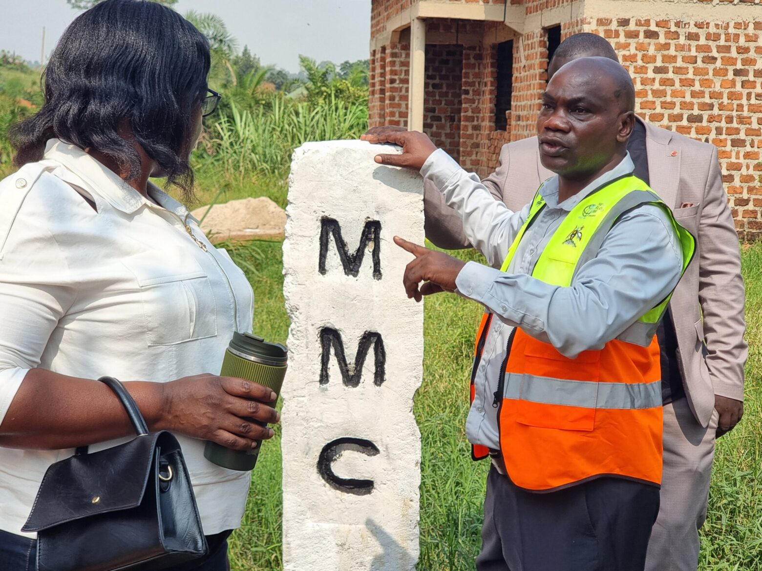
As part of the exercise, markstones have been installed at intervals of about 500 metres.
The stones are painted white and bear the initials “MMC”, representing Mukono Municipal Council. They are intended to provide physical reference points showing where municipal jurisdiction begins and ends.
For planners and enforcement officers, the significance of the stones goes beyond their physical appearance. They provide a reference against which development, construction, business operations and infrastructure can be assessed.
Christopher Mutumba, a law enforcement officer in the municipal physical planning department, said the exercise had already helped the municipality identify several major revenue-generating properties that had previously been administered by other local governments.
Among them are Igar Petrol Station, Nam-ruth Secondary School and factories in the industrial areas.
He said the exercise will enable municipal technical teams to plan with greater certainty because they can now establish whether a property falls within the municipality’s jurisdiction.
When one boundary cuts through a factory
The exercise has, however, also revealed a more complicated reality: administrative boundaries do not always neatly follow the walls of businesses or other developments.
Mutumba said some of the newly installed markstones have effectively divided major factories, leaving portions of the same establishments under different local government jurisdictions.
That creates another challenge: determining who collects which revenues and who is responsible for regulating and providing services to different parts of the same development.
Francis Byabagambi, the Mukono Municipal Town Clerk, said local governments would have to harmonise their revenue-collection arrangements where a development straddles administrative boundaries.
He said trading licence fees are generally paid to the local government where the business’s offices are located.
The clarification is expected to reduce the disputes that have characterised revenue collection along the municipal borders.
“Boundary marking is important; we have had some collisions in collecting revenue where entities have been raising concerns of extending to their premises and vice versa. But now all this has come to an end,” Byabagambi said.
The exercise therefore presents an opportunity not only to recover revenue but also to establish clearer rules on which authority is responsible for which services.
The planning implications
Local government boundaries determine much more than where taxes are paid.
They influence physical planning, road development, waste management, environmental enforcement, construction approvals, property valuation and the provision of public services.
Robert Peter Kabanda, the Mukono Municipal Mayor, said the boundary exercise was long overdue and could have prevented the municipality from losing strategic areas that are now being identified.
He pointed to a location along the Lake Victoria shoreline that can be accessed through Ssenyi-Degeya in Goma Division as one of the areas with potential strategic importance to the municipality.
Kabanda said the municipality would use information gathered during the exercise to identify service gaps and communicate them to central government.
“In many areas that had been previously left behind, services that are still needed and we are going to let the government know about them,” he said.
This could place new pressure on the municipality. Recovering an area administratively does not automatically mean that it has the roads, drainage systems, schools, health facilities, waste collection or other services expected of an urban authority.
The boundary exercise may therefore increase both the municipality’s revenue base and its obligations.
A gateway to Lake Victoria?
For Goma Division leaders, the exercise also carries a development dimension beyond taxation.
Kyasa said opening a road to the Lake Victoria shoreline would reduce transport costs and create opportunities for recreation and other economic activities.
He argued that access to the lake could give the municipality another gateway to the waters and potentially stimulate investment around the shoreline.
“We have talked about opening up the roadway to the lake. That will reduce the cost of transport. It will be a gateway to the waters in terms of recreation,” Kyasa said.
Such ambitions, however, will depend on whether the municipality can translate its newly clarified jurisdiction into coordinated physical planning and investment.
More than a line on a map
The boundary-marking exercise illustrates how unclear administrative borders can create problems that extend far beyond cartography.
For years, businesses and residents operating around Mukono’s boundaries may have faced uncertainty over which local government had authority over them. At the same time, neighbouring authorities could find themselves competing for property tax, trading licences and other revenues.
The new boundary markers are intended to provide a physical and technical solution to that uncertainty.
But the real test will come after the stones are installed.
Mukono Municipality will have to turn the newly confirmed territory into a stronger revenue base while ensuring that residents and businesses within the boundaries receive corresponding services.
Neighbouring local governments will similarly have to agree on practical arrangements where properties or developments cross administrative lines.
The discovery of previously overlooked commercial areas, industrial establishments and Zinga Island could therefore mark the beginning of a broader exercise in rethinking how Mukono Municipality plans and finances its growth.
For local leaders, the boundary is no longer simply a line separating one authority from another. It is becoming a tool for determining who plans, who collects revenue, who provides services and, ultimately, who takes responsibility for the rapidly expanding urban economy.
ENDS.













 English